Stine® Seed Company agronomists and sales reps are fielding calls from growers questioning whether it’s time to replant. This is especially timely across parts of the central and northern Corn Belt, where crusting or heavy moisture conditions have compromised plant stands. In many of these fields, replanting may seem like the obvious call, but it's not as simple as running the planter back through with the same population and product.
“Sometimes, you can do more damage to a field if you don’t map out a replant strategy,” says Susan Hart, Stine field agronomist. “You want to avoid making a hasty decision, so I recommend consulting with an agronomist to determine the best path forward. We can help you pinpoint the fine details, including which acres to replant, what product and maturity to use, and what population you should go in with.”
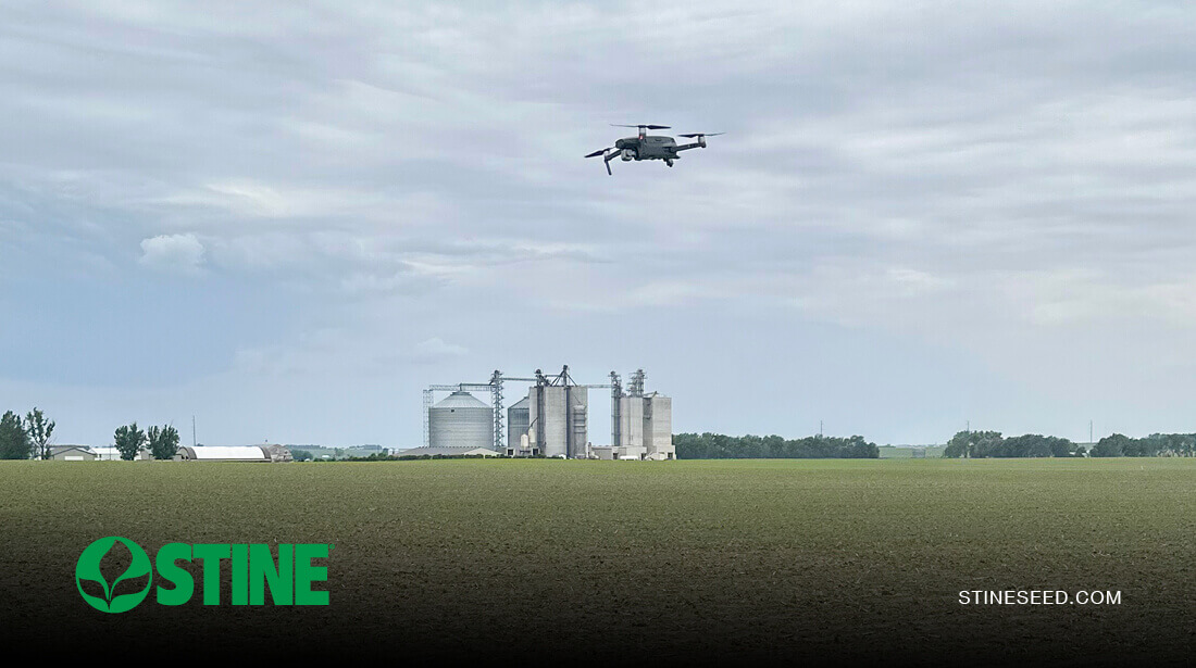
At Stine, our agronomy team uses a combination of boots-on-the-ground expertise, drone imagery and precision technologies to provide a more complete view of fields.
“Drone technology allows us to better define the problem areas in the field,” says Hart. “From there, we’re able to use a whole-system approach that includes aerial imagery, precision data and good-old-fashioned agronomic expertise to make a custom replant plan for each field.”
What aerial mapping tells us
Stine agronomists use drone technology for both research and development and crop scouting, capturing high-resolution aerial photography of each field. With continued advancements, image detail and accuracy are better than ever.
“This technology helps us track stand counts for yield analysis across every acre,” says Hart. “Each image breaks down vegetative stages, crop health, and areas where disease or pest pressure may be a concern. From a replant standpoint, drone imagery can accurately gauge planting efficiency, including planter performance, skips, emergence percentage, populations and more.”
Stine agronomists work with John Deere-owned Sentera, using its remote imagery solutions to conduct highly accurate aerial scouting with minimal flight time, which is critical with the narrow replant window.
“With Sentera technology, we can show up, fly the drone over the entire field in roughly 20–30 minutes, and then have imagery analyzed and a comprehensive replant strategy mapped out within a few hours,” says Hart. “The technology essentially provides real-time data in a matter of minutes that supports a broader prescription for your field.”
Identifying problem areas for replant
In recent weeks, Hart has worked with growers to pinpoint areas where replant was necessary and where it was not.
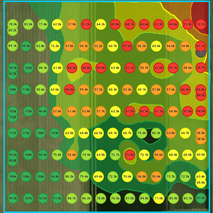
“The drones take about one picture per acre,” she says. “Then, the technology generates a heat map of the full field, indicating good stands in green and very poor stands in red. From there, I can create a zone map, which focuses more on the problem area and determines the population gap. You can even click into the images where poor stands are indicated, zoom in on the actual field photo and confirm the areas with poor stands.”
Hart has seen fields where frost damage impacted a portion, and the drone mapping outputs mirrored what would be expected from that kind of topography in a frost situation — confirming the accuracy of the data.
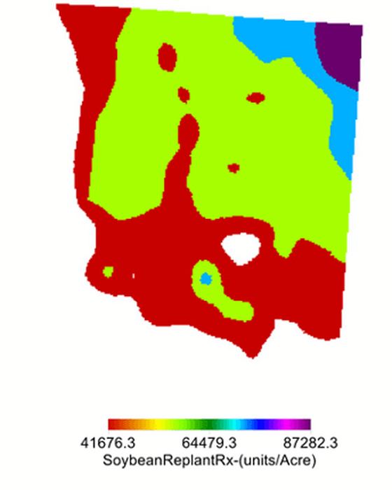
Once the images are completed, Hart imports the data into precision ag software and generates what she calls a Replant RX report. The report includes recommendations on where to replant and what population to use in specific areas.
“It creates a shapefile that the grower can plug into their equipment monitor,” says Hart. “For example, if you are only replanting 90 acres of a 130-acre field, the software tells the planter the seeding rate by zone with georeferenced data.”
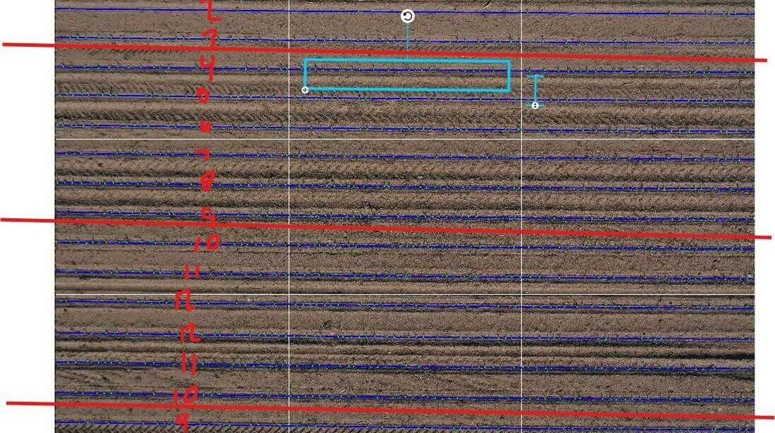
Another valuable feature is the system’s ability to zoom in on problem areas, helping farmers determine when replanting is unnecessary.
“There have been instances where growers noticed emergence issues at the edge of a field, but using drone technology and high-resolution imagery, we could see that stand loss was limited to that area and didn’t warrant a full replant,” says Hart. “We could also zoom in on the imagery and see where compaction caused by tire and planter tracks was the contributing factor.”
The value of a replant prescription
The prescription mapping Stine agronomists can generate for replant decisions isn’t just valuable for determining planting recommendations by field zone; it can also help reduce costs by allowing growers to replant only where it’s economically beneficial.
“The best part is that we’re not guessing on seeding rate, population or how many units to use,” says Hart. “Based on this technology, we know exactly how many seeds and seed units we’ll need to purchase for the replant pass. You save money on seed, fuel and time in the field because you aren’t guessing — you have clearly defined planting rates and georeferenced data that put you in the field with a solid plan.”
Drones also save time in the field with faster and more accurate stand counts versus hand-counting. The data can also provide insights that deliver value in the next crop year.
“Drone scouting paired with in-field scouting can help identify issues related to specific row units, planting depth, compaction and planter skips — giving you valuable information to better prepare for the next season,” says Hart. “For example, it might tell you to adjust your planting depth or invest in planter maintenance before you hit the fields next spring. It gives you solutions for right now but also for the future.”
While drone technology doesn’t replace boots-on-the-ground support, it helps growers use data to make more informed decisions.
To learn more about Stine’s use of drone technology for crop scouting or to discuss a potential replant decision, contact your local Stine sales rep.